This could also be called “the Johnson County Connector”–as its primary purpose is to define a good route from Northeast Johnson County to Downtown. It just so happens that takes you within a few blocks of (but never on) State Line Road.
The first half is bucolic, taking you along scenic and quiet residential streets in Mission Hills, Fairway, Westwood and KCK.
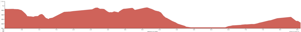
Belinder Avenue serves as a rare JoCo biking and walking corridor and also the starting point for Route A. North of 63rd Street it dives into the hilliest part of Mission Hills, twisting and winding along several streets until linking up in Fairway with Belinder again. A steep, long grade brings you to one of the easier crossings of Shawnee Mission Parkway.
Route A continues on Belinder through Westwood and then turns right on 47th Street, where there are a series of short jogs designed to avoid busy intersections and provide a safe crossing of busy Rainbow Boulevard.
The jogs continue on 45th Avenue east of Rainbow until you cross into Missouri and into the State Line Antique District. The route here is designed to get you into Roanoke Park with as few dangerous intersections as possible.
In Roanoke, you hurtle down Wyoming Street and continue down this long, steep grade through the small industrial district on Roanoke Road. At the Southwest Boulevard, you pick up a tolerable dedicated bike lane, which almost gets you into the Crossroads. The bike lanes on 20th bring you to Walnut, our preferred north/south street and on into Downtown.
On a fast e-bike, it’s about 30 minutes Northbound, and due to the steep hill you have to climb, a little longer Southbound.
Route A: The State Liner
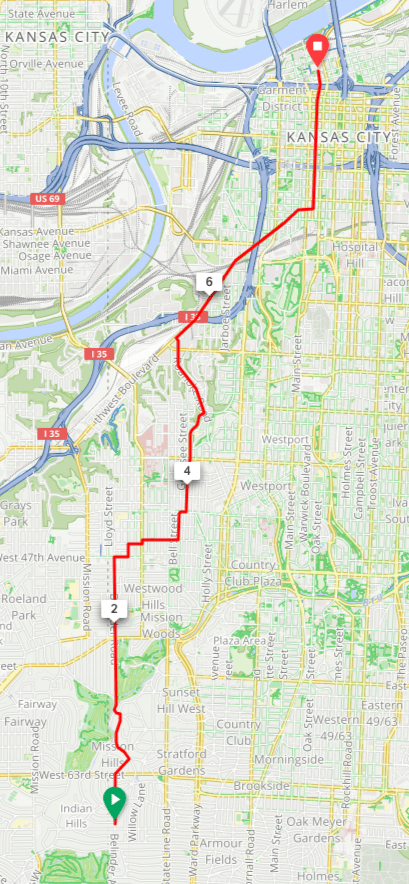
Length: 8.0 miles
Efficiency: 95%
Route Advisories: